One of the many social studies standards for our fifth graders is learning about the three branches of government. While this has been one of my favorite teaching resources from Lakeshore, I have added to this kit over the years:
We read about the three branches, made a foldable, and did a 3D tour of Washington DC using Google Earth. My partner teacher, Mrs. H, had a fantastic idea of contacting her cousin, Mrs. W who works for one of our nation's governors.
So, without telling our students, we enlisted the help of our school's digital coach to set up a Skype call with her. It was a fairly easy process once we found all the proper cords and did a test run with the iPads.
We casually mentioned the upcoming Skype call to our students a few days before it happened. Hey, we're calling Washington DC to chat about our nation's government. No big deal, just a typical day in the fifth grade.
They brainstormed questions which ranged from incredibly thoughtful (Which branch of government is your favorite?) to a tad silly (Have you met the first dog? Mind you, the dog. Not the President or First Family, they were only concerned about the First Pets.) Mrs. W was incredibly patient with them and answered all their questions. They loved it!
Huge shout out to my partner teacher Mrs. H and her wonderful cousin for letting our fifth graders Skype it up and enhance their learning.
Showing posts with label Google Earth. Show all posts
Saturday, May 23, 2015
Friday, June 20, 2014
What? You've Never Seen This?
Now that it's summer break, I have time to reflect upon yet another year in the classroom. This year was my most challenging yet and for that, I am grateful.
I have some definite face-palm moments in my classroom.
Sometimes I forget that things I assume are common knowledge just...aren't.
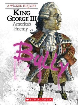
The first of many, many moments was when I had to clarify that kings and queens do actually exist. We were reading informational text on the American Revolution, which naturally included a discussion on King George III. This was our mentor text:
They really enjoyed reading and analyzing this passage, although the language and vocabulary did provide some stumbling blocks. However, through discussion, I realized that many of them were confused. They knew the passage we were reading was true and based on facts because it's informational text (hallelujah they've got that down), but were "clunking" on the king label. They didn't realize that kings and queens were real. So after a quick discussion that included yes, kings are real and no, dragons aren't, they seemed to be more okay with the topic.
Apparently they then all went out to recess and informed the other fifth graders, thus ending their confusion as well. Kings did (and do) exist. Glad that's cleared up.
Second, some didn't realize World War Two actually occurred at all, much less (potentially) within their grandparents' lifetime. We were reading Number the Stars and I set the necessary historical background. We looked at some maps (okay Google Earth...it's much more interactive) and took a virtual field trip of Copenhagen.
Then some of my higher students, who have read Number the Stars earlier in the year made the connection that wait, this was based on true events. Another made the connection to some video game, which sparked a class-wide discussion. Next time, I think I'll start with the video game reference since that made a lot more sense to many of them.
Live, learn, and teach on!
I have some definite face-palm moments in my classroom.
Sometimes I forget that things I assume are common knowledge just...aren't.
The first of many, many moments was when I had to clarify that kings and queens do actually exist. We were reading informational text on the American Revolution, which naturally included a discussion on King George III. This was our mentor text:
They really enjoyed reading and analyzing this passage, although the language and vocabulary did provide some stumbling blocks. However, through discussion, I realized that many of them were confused. They knew the passage we were reading was true and based on facts because it's informational text (hallelujah they've got that down), but were "clunking" on the king label. They didn't realize that kings and queens were real. So after a quick discussion that included yes, kings are real and no, dragons aren't, they seemed to be more okay with the topic.
Apparently they then all went out to recess and informed the other fifth graders, thus ending their confusion as well. Kings did (and do) exist. Glad that's cleared up.
Second, some didn't realize World War Two actually occurred at all, much less (potentially) within their grandparents' lifetime. We were reading Number the Stars and I set the necessary historical background. We looked at some maps (okay Google Earth...it's much more interactive) and took a virtual field trip of Copenhagen.
Then some of my higher students, who have read Number the Stars earlier in the year made the connection that wait, this was based on true events. Another made the connection to some video game, which sparked a class-wide discussion. Next time, I think I'll start with the video game reference since that made a lot more sense to many of them.
Live, learn, and teach on!
Labels:
American Revolution,
clunks,
Google Earth,
history,
informational text,
maps,
Number the Stars,
reflection,
summer,
teachable moment,
technology,
these are my students,
virtual field trip
Saturday, September 28, 2013
Land Forms
We've been studying land forms for a few weeks now in science. We've learned all about different types of maps, made several different versions and observed how elevation can change a stream table.
Next week, we are going to conduct more stream table experiments, this time with flash floods. (One time with no elevation, one time with elevation to see the difference). From there, we'll discuss more vocabulary, look at Google Earth for land forms and learn about layers of the earth. Then, after we co-construct our anchor charts, we'll learn about the ring of fire and tectonic plates.
I saw this idea on pinterest and I think it's a perfect Friday science activity:
I'm totally game for combining food and science, it's hands-on, edible learning at its finest!
Next week, we are going to conduct more stream table experiments, this time with flash floods. (One time with no elevation, one time with elevation to see the difference). From there, we'll discuss more vocabulary, look at Google Earth for land forms and learn about layers of the earth. Then, after we co-construct our anchor charts, we'll learn about the ring of fire and tectonic plates.
I saw this idea on pinterest and I think it's a perfect Friday science activity:
I'm totally game for combining food and science, it's hands-on, edible learning at its finest!
Friday, July 26, 2013
Map-a-poluzza!
I might be the rare one here, but I love teaching geography, history, government and really anything to do with maps. My grade level happily appointed that FOSS science kit to me (well, land forms) because for some weird reason, being a cartographer and making sand models only appeals to me and my inner five year old.
For fifth grade purposes, we go over physical, political and topographic maps. We use post cards from around the world to examine different land forms, learn about the fifty states and regions of the US. We use this map and the matching world version to go over political maps, focusing on state and international boundaries along with capital cities:
(Map is from FAO Schwartz, but the Discovery Channel makes a very similar one that is not only less expensive, but usually on sale at Kohls!)
We use our globe, atlases and old-school pull down maps to go over the physical features of the earth (land forms) and visit both using the different layers on Google Earth.
If you haven't played with the 3D buildings, I highly recommend it! We used it for looking at the monuments in Washington DC and for exploring the remains of the Titanic. There are also premade tours on Google Earth, which you can access in the gallery or clicking the tour button under "my places"
The topographic maps are included in our FOSS science kit, but I extend the learning by printing out topographic maps of our area so the kids can make connections with our own mountains. Mount Shasta, as nifty as it is, doesn't have the same connection as our own Mt. Charleston in Las Vegas.
Besides exploring our surrounding neighborhood and US land forms, we also use Google Earth for virtual field trips. A favorite is to visit the moon and Mars :)
On the Google Tool Navigation Bar, select the planet and pull down to visit the moon, Mars or the sky. The default setting is our own planet but you can go elsewhere.
Since I'm in charge of reviewing the solar system, it makes perfect sense for me to take my little astronauts on a virtual trip to Olympus Mons, Mars. We talk about the name, make the connection to Mount Olympus (since they study Greek mythology in fourth grade) and they absolutely love it. I often have to shoo them out of my room come recess time so I can eat.
When we talk about land forms, volcanoes inevitably come up. While I'm not opposed to the traditional baking soda, red food coloring & vinegar "volcano explosion", that experiment is part of another science kit. So instead, we visit the volcano builder website and play with virtual volcanoes.
The students learn the vocabulary associated with volcanoes (viscosity, magma, etc) as well as the classification of types of volcanoes. They make predictions about the types of explosions that will occur when the pressure and viscosity levels are changed. We also watch volcanic eruptions and discuss the geological processes that are occurring A tip I picked up from Discovery Education is to play the video clip on silent and have students narrate what is happening on the condition that they use the academic vocabulary. We use Discovery Education and PBS video streaming, but teacher tube, you tube, National Geographic and other sites have similar footage.
To check their understanding of maps, I created a sort which is available on TpT. Hopefully your students love earth science as much as mine :) You've got to put the joy in teaching and if tech toys don't do it for you, find something that does.
Monday, July 15, 2013
I Have, Who Has? Landforms
Our grade level decided to try something new for science this year. Each one of us is teaching a different science concept and I have land forms :)
I love teaching land forms!
I get to review the solar system, structures of the earth, geography, mapping skills and much, much more! We use Google Earth to take virtual tours of the world and use the time lapse feature to watch the Grand Canyon erode over time.
I love to start the unit with images like this:
Or...
And...
to peak their interests! Since we live in a desert, my students have really only seen the mountains and sand. Some have been to lake beaches but very few have experienced other land forms. Thus, we use a lot of Google Earth to bring the world inside our classroom.
Of course, whenever possible, we use food as well:
Plate tectonics have never been so yummy :)
To help my students review vocabulary words, I made a "I have, who has" station that can be used in whole or small groups. It's a great review of crucial vocabulary and can be used as test prep! If you'd like your own copy, it's available here for your science pleasure!
Labels:
centers,
Google Earth,
land forms,
science,
TpT,
vocabulary
Subscribe to:
Posts (Atom)